


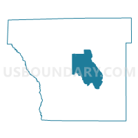
Smith Voting District, Cleveland County, Arkansas
About
Outline

Summary
| Unique Area Identifier | 526168 |
| Name | Smith Voting District |
| County | Cleveland County |
| State | Arkansas |
| Area (square miles) | 40.57 |
| Land Area (square miles) | 40.47 |
| Water Area (square miles) | 0.10 |
| % of Land Area | 99.76 |
| % of Water Area | 0.24 |
| Latitude of the Internal Point | 33.88850920 |
| Longtitude of the Internal Point | -92.13838600 |
Maps

Graphs
Select a template below for downloading or customizing gragh for Smith Voting District, Cleveland County, Arkansas


Neighbors
Neighoring Voting District (by Name) Neighboring Voting District on the Map
- Harper Voting District, Cleveland County, AR
- Kingsland Voting District, Cleveland County, AR
- Miller Voting District, Cleveland County, AR
- Redland Voting District, Cleveland County, AR
- Rison Voting District, Cleveland County, AR
- Rison Ward A, Cleveland County, AR
- Rowell Voting District, Cleveland County, AR
Top 10 Neighboring County Subdivision (by Population) Neighboring County Subdivision on the Map
- Rison township, Cleveland County, AR (1,522)
- Kingsland township, Cleveland County, AR (1,006)
- Miller township, Cleveland County, AR (663)
- Redland township, Cleveland County, AR (622)
- Harper township, Cleveland County, AR (538)
- Smith township, Cleveland County, AR (424)
- Rowell township, Cleveland County, AR (395)